| Day -1, Thursday April 1, 1999 |
|
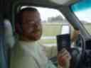
My very first day at IMI was April 1st, 1998. My last day is going to
be Friday April 2nd, 1999. Kat and I have rented a 15' Ryder moving
truck which I picked up after work, and we have 12 days to drive from
Jupiter, Florida, to Vancouver, B.C. Total cost with full insurance
is somewhere around 1900US$, which is much less than what it would
cost to get a moving company to do the job.
We've been quite busy lately, packing the apartment, tying up loose
 ends, and saying good-bye to friends and co-workers. Two weekends ago,
just after we made the decision to move, we drove to Pahokee on
Saturday morning for some skydiving and then spent the rest of the
weekend on the gulf coast digging for sand dollars and kayaking with
the manatees. Now we try to come to grips with the fact that in less
than 2 weeks, we'll be soaking our feet in the Pacific instead of the
Atlantic.
ends, and saying good-bye to friends and co-workers. Two weekends ago,
just after we made the decision to move, we drove to Pahokee on
Saturday morning for some skydiving and then spent the rest of the
weekend on the gulf coast digging for sand dollars and kayaking with
the manatees. Now we try to come to grips with the fact that in less
than 2 weeks, we'll be soaking our feet in the Pacific instead of the
Atlantic.
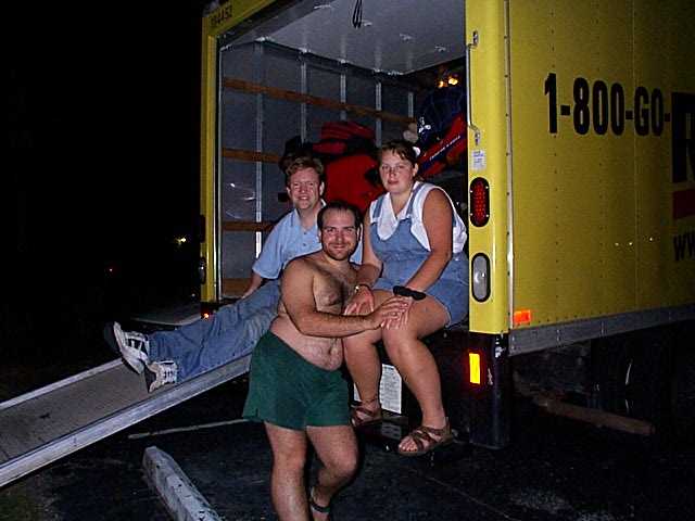
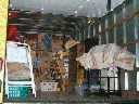
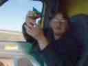
Tonight, Dave L., Dave A. & Melanie, and of course Kat and I, spent
the evening packing the truck. Eight hours, 2 large pizzas and 4L of
pop later, almost everything we own has been packed into the truck.
Kat and I will finish up the small stuff tomorrow after work. |
|
| Day 0, Friday April 2, 1999 |
 While I had initially planned on leaving tonight, we never finished what
we needed to do until close to 23:00. Dave invited us over to his place,
where we'll spend the night before leaving early next morning. This will
be our last night in Florida.
While I had initially planned on leaving tonight, we never finished what
we needed to do until close to 23:00. Dave invited us over to his place,
where we'll spend the night before leaving early next morning. This will
be our last night in Florida. |
|
| Day 1, Saturday April 3, 1999 |
|
Looking back at things, Saturday came and went rather fast. We skipped
through Florida, and travelled through most of Georgia. The first thing
we noticed in Georgia when we stopped to stretch our legs was: Wow!
They have real grass! Those of you who have spent time in Florida
must have noticed that what they call "grass" is actually sharp pieces
of thick green fibers that can poke holes in 3" thick steel plates.
(As an append, David Aaronson tells me that it is
called Saint Augustine Grass.)
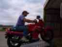
 At night, we pulled off I75 at one of the service areas along the highway,
and I drove the motorcycle out from the back of the truck. We then put
the futton down in back, closed the door almost all the way, and tried to
sleep. Just last summer, I had been backpacking not too far from here
with some friends from work.
At night, we pulled off I75 at one of the service areas along the highway,
and I drove the motorcycle out from the back of the truck. We then put
the futton down in back, closed the door almost all the way, and tried to
sleep. Just last summer, I had been backpacking not too far from here
with some friends from work.
(34° 24' 34"N, 84° 55' 7"W, 682 miles completed today) |
|
| Day 2, Sunday April 4, 1999 |
Sunday
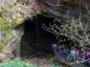 took us through Chattanooga, Tennessee on I24, our first timezone
change, and into Kentucky on I65 to the world's largest cave system at
Mammoth Cave National Park. We spent a few hours taking a tour in the
first few levels of the caves, which proved to be quite exciting. By
this time, we could start to feel a real change in weather. No more
palm trees (those had been left behind even before we crossed into
Georgia I think), not even any leaves in the trees.
took us through Chattanooga, Tennessee on I24, our first timezone
change, and into Kentucky on I65 to the world's largest cave system at
Mammoth Cave National Park. We spent a few hours taking a tour in the
first few levels of the caves, which proved to be quite exciting. By
this time, we could start to feel a real change in weather. No more
palm trees (those had been left behind even before we crossed into
Georgia I think), not even any leaves in the trees.
From Cave City (which doesn't qualify for the name 'city') we headed back
down to Bowling Green, back to Cave City (don't
ask...that guy thing about asking directions, and maybe we really did
want to see the countryside for 2 hours on roads that have no names, just
4- and 3-digit identifiers) and eventually found our way to
Green River Pkwy through a corner of Indiana and Illinois, onto I64 were
we slept for the second night in the truck.
(38° 13' 54"N, 87° 59' 20"W, 521 miles completed today) |
|
| Day 3, Monday April 5, 1999 |
|
We crossed Illinois pretty quickly -- probably because we couldn't find a
reason to stop. Note: do not pass Mt. Vernon on an empty gas tank --
there really is nothing else in the middle of the state.
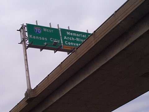
The
 famous Arch of St. Louis, on the banks of the Mississippi kept us for a
few hours, before we continued across Missouri on I70 towards Kansas City.
Unless I'm mistaken, the same note applies to most of Missouri. Other
than the town of Boonville (I'm not
kidding about the name!) halfway across the state, there really
wasn't much to see. We spent our third night in the truck in yet another
service station on I29 just past the Iowa border. By this time, Kat and I
were thinking up of word games and puzzles to keep us occupied. Huh,
maybe to keep me awake too. :)
famous Arch of St. Louis, on the banks of the Mississippi kept us for a
few hours, before we continued across Missouri on I70 towards Kansas City.
Unless I'm mistaken, the same note applies to most of Missouri. Other
than the town of Boonville (I'm not
kidding about the name!) halfway across the state, there really
wasn't much to see. We spent our third night in the truck in yet another
service station on I29 just past the Iowa border. By this time, Kat and I
were thinking up of word games and puzzles to keep us occupied. Huh,
maybe to keep me awake too. :)
Dave A.: yeah, that gas peddle is becoming harder and harder to hold
down. By this time, I'd discovered the secret technique of wedging my
foot between the gas peddle and the bottom panel of the dashboard, which
served as a kind of cruise control.
(41° 4' 48"N, 95° 49' 33"W, 521 miles completed today) |
|
| Day 4, Tuesday April 6, 1999 |
|
We've had the truck for 1/2 of our alloted 12 days, and I must say that
I'm getting really nervous. We drive through Dave's home state of Iowa,
and turn West at Sioux Falls on I90 to South Dakota. Now, when Kat and I
previously thought that parts of IL and MO took a long time...!
Dave L.: you were right; the Corn Palace in Mitchell is the only
thing in the first half of the state! We didn't stop; driving by was
plenty for us. For those of you with no knowledge of the Corn Palace --
it is a building entirely built (or just decorated?) with corn. No
further comment; you'll just have to drive there to see it.
The
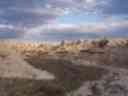
 second half of South Dakota, however, is where the real nice part of
the trip started. We took a detour on Hwy 240 through Badlands National
Park. This is REALLY worth it! I'd seen what they called the
Badlands in Alberta, but it doesn't compare to this area! That night,
for the first time on our trip since leaving Dave's house on Saturday, we
slept in a motel in Rapid City.
second half of South Dakota, however, is where the real nice part of
the trip started. We took a detour on Hwy 240 through Badlands National
Park. This is REALLY worth it! I'd seen what they called the
Badlands in Alberta, but it doesn't compare to this area! That night,
for the first time on our trip since leaving Dave's house on Saturday, we
slept in a motel in Rapid City.
(583 miles completed today) |
|
| Day 5, Wednesday April 7, 1999 |
Being
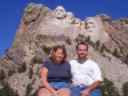
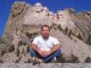 in this neck of the woods, we took a detour on Hwy 16 to go see
Mount Rushmore. It is one thing being in grade school and hearing about
it (you must remember I spent grades 2 to 5 in New
York) and completely different to be standing before it.
:) Note for future reference:
Kathie, I promise, we'll go back some day while on vacation and
check out the famous Jewel Caves, Wind Caves, et al...
:)
in this neck of the woods, we took a detour on Hwy 16 to go see
Mount Rushmore. It is one thing being in grade school and hearing about
it (you must remember I spent grades 2 to 5 in New
York) and completely different to be standing before it.
:) Note for future reference:
Kathie, I promise, we'll go back some day while on vacation and
check out the famous Jewel Caves, Wind Caves, et al...
:)
The
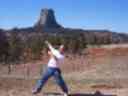 rest of the day was rather strange...we diverted way off the
route you'd think we'd have taken. After leaving SD on I90 to go to
Wyoming, we took route 14 to route 24, past Devils Tower National Monument
and up route 112 into the town of Alzada (pop.
16?), Montana, before heading up on I212 to rejoin I90 at Crow
Agency. Even though we weren't on the highway, the lack of a speed limit
in Montana, the flat and even road, and virtually no traffic all
afternoon, provided ideal conditions. Even for a fully loaded 15' truck.
And the 14 miles of construction and gravel roads somewhere between
Ashland and Lame Deer. Yes, you read that correctly, there actually is a
town called Lame Deer. If you blink twice, you'll drive right through it,
so pay attention!
rest of the day was rather strange...we diverted way off the
route you'd think we'd have taken. After leaving SD on I90 to go to
Wyoming, we took route 14 to route 24, past Devils Tower National Monument
and up route 112 into the town of Alzada (pop.
16?), Montana, before heading up on I212 to rejoin I90 at Crow
Agency. Even though we weren't on the highway, the lack of a speed limit
in Montana, the flat and even road, and virtually no traffic all
afternoon, provided ideal conditions. Even for a fully loaded 15' truck.
And the 14 miles of construction and gravel roads somewhere between
Ashland and Lame Deer. Yes, you read that correctly, there actually is a
town called Lame Deer. If you blink twice, you'll drive right through it,
so pay attention!
 That night, we slept in the truck again -- for the last time -- just
past Billings, Montana.
That night, we slept in the truck again -- for the last time -- just
past Billings, Montana.
(521 miles completed today) |
|
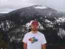
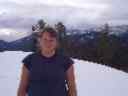
| Day 6, Thursday April 8, 1999 |
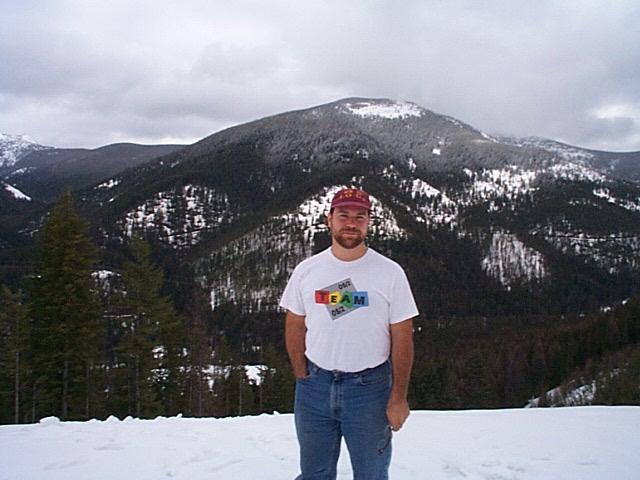
Today
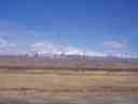
 was the first day we saw the real mountains. Again for me, and
the first time for Kat. Montana is a fairly long state to cross, and
even when starting from halfway across at Billings, we didn't get out
of the first mountain range until late afternoon. We'd seen a few
patches of snow on the ground starting 2 days ago in South Dakota, but
Montana provided us with our first snow-covered peaks.
was the first day we saw the real mountains. Again for me, and
the first time for Kat. Montana is a fairly long state to cross, and
even when starting from halfway across at Billings, we didn't get out
of the first mountain range until late afternoon. We'd seen a few
patches of snow on the ground starting 2 days ago in South Dakota, but
Montana provided us with our first snow-covered peaks.
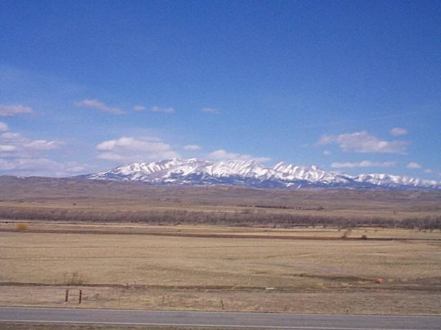
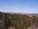
The picture to the left is of Crazy Woman Mountains as seen from
Big Timber, MT, but the story lost its appeal after I heard the
part where her second husband went around eating the livers of the
indians he killed to avenge her death.
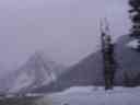
Crossing the pass into Idaho, we witnessed our first real winter scene,
 with actual snow banks, and runaway truck lanes at the bottom of hills
with double-digit inclines! Stopping for dinner in Coeur d'Alene, on
the border between Idaho and Washington, I finally felt like I was close
to Vancouver again. Kat, on the other hand, was getting more nervous
with every mile closer to the Canadian-American border.
:)
with actual snow banks, and runaway truck lanes at the bottom of hills
with double-digit inclines! Stopping for dinner in Coeur d'Alene, on
the border between Idaho and Washington, I finally felt like I was close
to Vancouver again. Kat, on the other hand, was getting more nervous
with every mile closer to the Canadian-American border.
:)
That night, we slept in a motel in Ellensburg, halfway through the state
of Washington. Today was the longest drive during our trip, and this
night will be the last one we spend in the U.S.
(658 miles completed today) |
|
| Day 7, Friday April 9, 1999 |
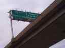
We
 made our way through snow storms and slush-covered roads in the
Washington mountains, and turned north on I5. I saw one highway sign for
an exit to Redmond, and I'm pretty sure the engine coughed a few times.
Or maybe it was just me coughing. After 1 month of planning, and almost
4000 miles, I finally feel like the trip is coming to a close. Up ahead,
not more than five cars are before us in line to cross the U.S.-Canada
border.
made our way through snow storms and slush-covered roads in the
Washington mountains, and turned north on I5. I saw one highway sign for
an exit to Redmond, and I'm pretty sure the engine coughed a few times.
Or maybe it was just me coughing. After 1 month of planning, and almost
4000 miles, I finally feel like the trip is coming to a close. Up ahead,
not more than five cars are before us in line to cross the U.S.-Canada
border.
It
 actually turned out to be very simple: the border guards asked us how
long we'd been there, how long we'll be here, to which we replied
something to the effect of "1 year/my whole life, 6 months/I don't know",
they looked at the motorcycle, asked me to pay a 200$
(Canadian dollar! I had forgotten what they looked
liked!) vehicle import fee, stamped a lot of papers, and sent us on
our way! It really helped to be prepared; I had downloaded all of the
forms beforehand from the Canadian Customs web site, and they were all
filled out, which I believe that guards took to view as "this guy knows
what he's doing, let him through..." Little did they know!
actually turned out to be very simple: the border guards asked us how
long we'd been there, how long we'll be here, to which we replied
something to the effect of "1 year/my whole life, 6 months/I don't know",
they looked at the motorcycle, asked me to pay a 200$
(Canadian dollar! I had forgotten what they looked
liked!) vehicle import fee, stamped a lot of papers, and sent us on
our way! It really helped to be prepared; I had downloaded all of the
forms beforehand from the Canadian Customs web site, and they were all
filled out, which I believe that guards took to view as "this guy knows
what he's doing, let him through..." Little did they know!
Eric: that paper you signed for me saying "Stéphane has been here
for 1 year and IMI releases him of all duties and obligations"
saved my day! They asked for exactly that; took one look at it,
brought out the rubber stamp, and said "OK!"
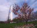
We drove up to Vancouver, picked up a paper, booked ourselves into a
motel on Kingsway, and started looking for apartments! Seven days ago,
we left the Atlantic, and today, Kat saw the Pacific for the first
time; I hadn't seen it for just slightly over 1 year. Welcome home!
(49° 13' 55"N, 122° 59' 21"W, 411 miles completed today) |
|
| Post-Trip Information |
|
We saw 4 apartments in 2 days once we were in Vancouver; one near SFU,
another in Westend, one in Point Grey, and the last in Burnaby. Pretty
much all four suburbs next to Vancouver. The last one, near Royal Oak
Skytrain station in Burnaby, is the one we chose on Saturday. We took 3
days to empty the truck, and I started work at HSBC on Monday morning,
just 2 days after being back in the country!
The computer was hooked up the following Thursday, and that weekend we
downloaded from the digital camera more than 200 pictures we took during
the trip. Wow! :) But there are
more than 30MB worth of images, which has taken me some time to convert
to a viewable web page. Hope the wait has been worthwhile.
(3897 miles completed in 7 days) |
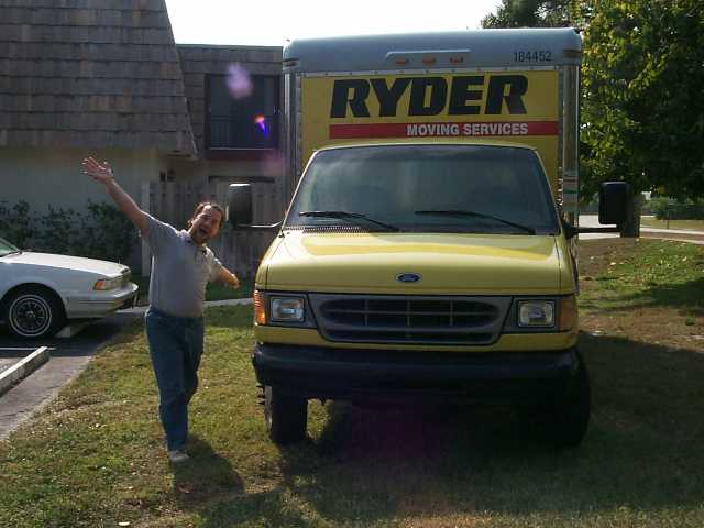 Kat -- have decided to leave the gator-plagued land of the sun and head
Northwest towards the ocean city of Vancouver. A very bright yellow truck
has been rented for a too-large sum of American money; our home for the
next 12 days. Friday was my last official day of work at IMI, as well as
Kat's at the daycare in Jupiter. We finished packing, cleaned up the
apartment, and now we're ready to leave early tomorrow monring, Saturday
April 3rd, 1999.
Kat -- have decided to leave the gator-plagued land of the sun and head
Northwest towards the ocean city of Vancouver. A very bright yellow truck
has been rented for a too-large sum of American money; our home for the
next 12 days. Friday was my last official day of work at IMI, as well as
Kat's at the daycare in Jupiter. We finished packing, cleaned up the
apartment, and now we're ready to leave early tomorrow monring, Saturday
April 3rd, 1999.